


100226 5th Annual GEO-CT Conference
The CT Valley Chapter of the ASCE Geo-Institute invites you to its 5th Annual Fall 2026 GEO-CT Conference on Friday, October 2, 2026, at the Sheraton Hartford South in Rocky Hill, CT. Seven (7) New York State PDHs will be offered at this event.
Conference Program and Exhibitor Layout 
Thank you to our sponsors!

Keynote Speaker: Kord Wissmann, Ph.D., P.E., BC.GE, Intechnics
Kord J. Wissmann, Ph.D., P.E., BC.GE is the founder of Intechnics, Inc., a geotechnical engineering consulting company based in Mooresville, North Carolina. Kord has more than 35 years of experience in geotechnical engineering as a consultant, designer, and specialty contractor. From 2002 until 2024, Kord led specialty foundation contractor Geopier Foundations with a focus on developing and engineering ground improvement alternatives to traditional foundation options. Under Kord’s leadership, Geopier has expanded to provide multiple ground improvement systems applied to projects in 33 countries over six continents. Kord holds 30 U.S. patents, has authored more than 35 papers, and is a past president of the Geo-Institute. Kord holds a Bachelor of Science and Doctorate degrees in Civil Engineering from Virginia Tech and a Master of Science in Civil Engineering from the University of California, Berkeley. Prior to joining Geopier, Kord held positions with Harding Lawson Associates, Fluor Daniel, and Shannon & Wilson, Inc.
Geo-Innovations - How far we've traveled in just 3 years - Now what?

Arsanious Guirguis, P.E., H&H
Arsani is a Senior Principal Geotechnical Engineer at H&H's with over 15 years of hands-on experience in designing and managing the construction of foundations and substructures for a wide range of bridges across the Northeast. His portfolio includes movable bridges, highway overpasses, and railway viaducts. Arsani specializes in soil-structure interaction, deep foundation design, slope stability, retaining wall design and ground improvement techniques. Beyond design, he has a strong background in delivering design-build projects. A graduate of NJIT, where he earned both his bachelor’s and master’s degrees, Arsani also shared his knowledge as an adjunct professor at TCNJ for two years.
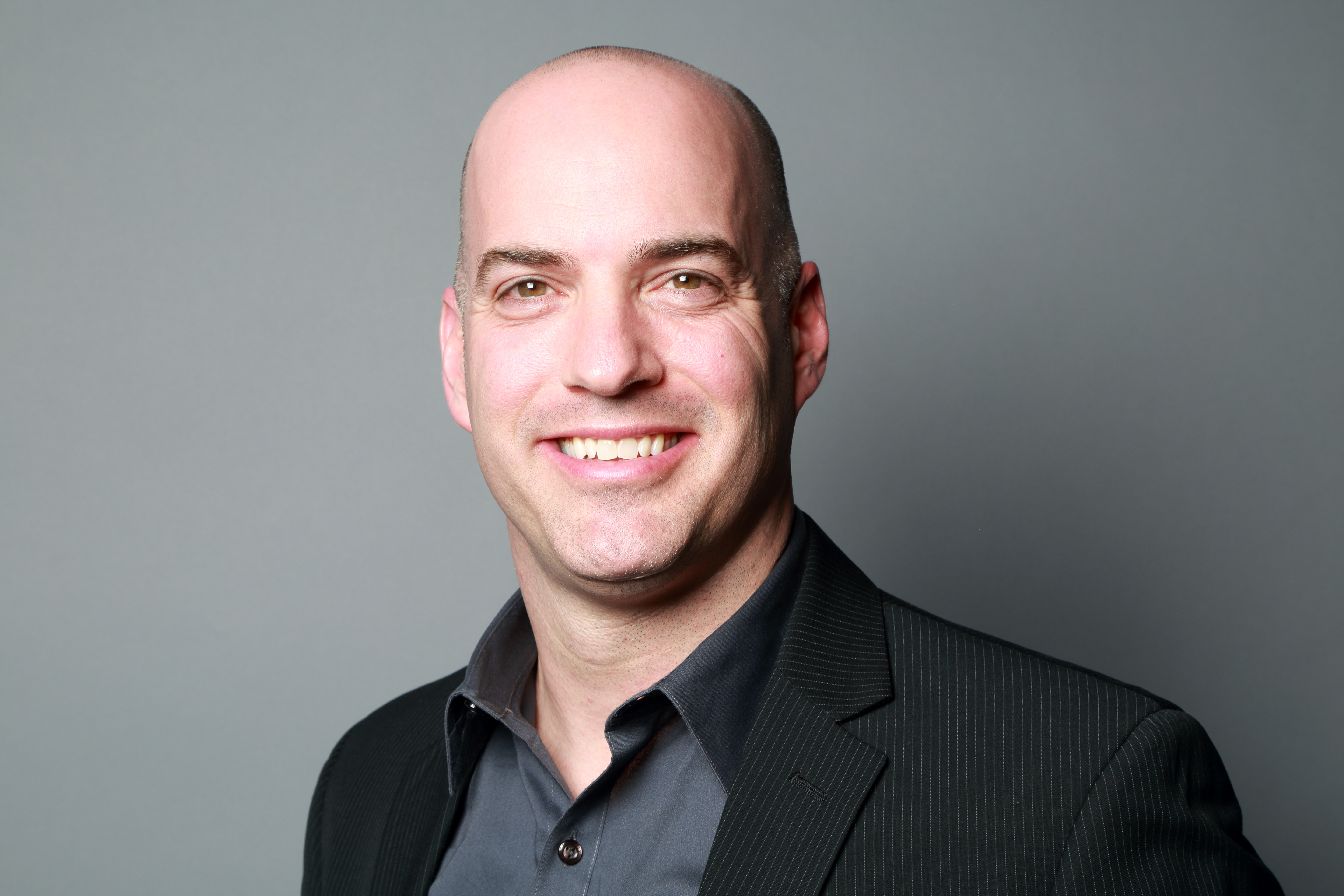
Brian Mileo, P.E., H&H
Brian Mileo is a senior principal engineer specializing in the design of complex fixed structures for both highway and rail infrastructure. His 27 years of experience encompasses bridge analyses, design development of new and rehabilitation/replacement of existing structures, and bridge inspection of various types and sizes including waterway and railroad crossings, multi-girder bridges, and trusses. Brian has worked in all phases of project development – from concept development through design and construction support services. His extensive construction support experience includes performing shop visits during fabrication of steel superstructures, as well as site visits during span erection, bearing and joint installations, concrete deck pours to ensure compliance with design specifications, and constructability assessment.
Supporting the New Raritan River Bridge: A Deep Foundation Case Study
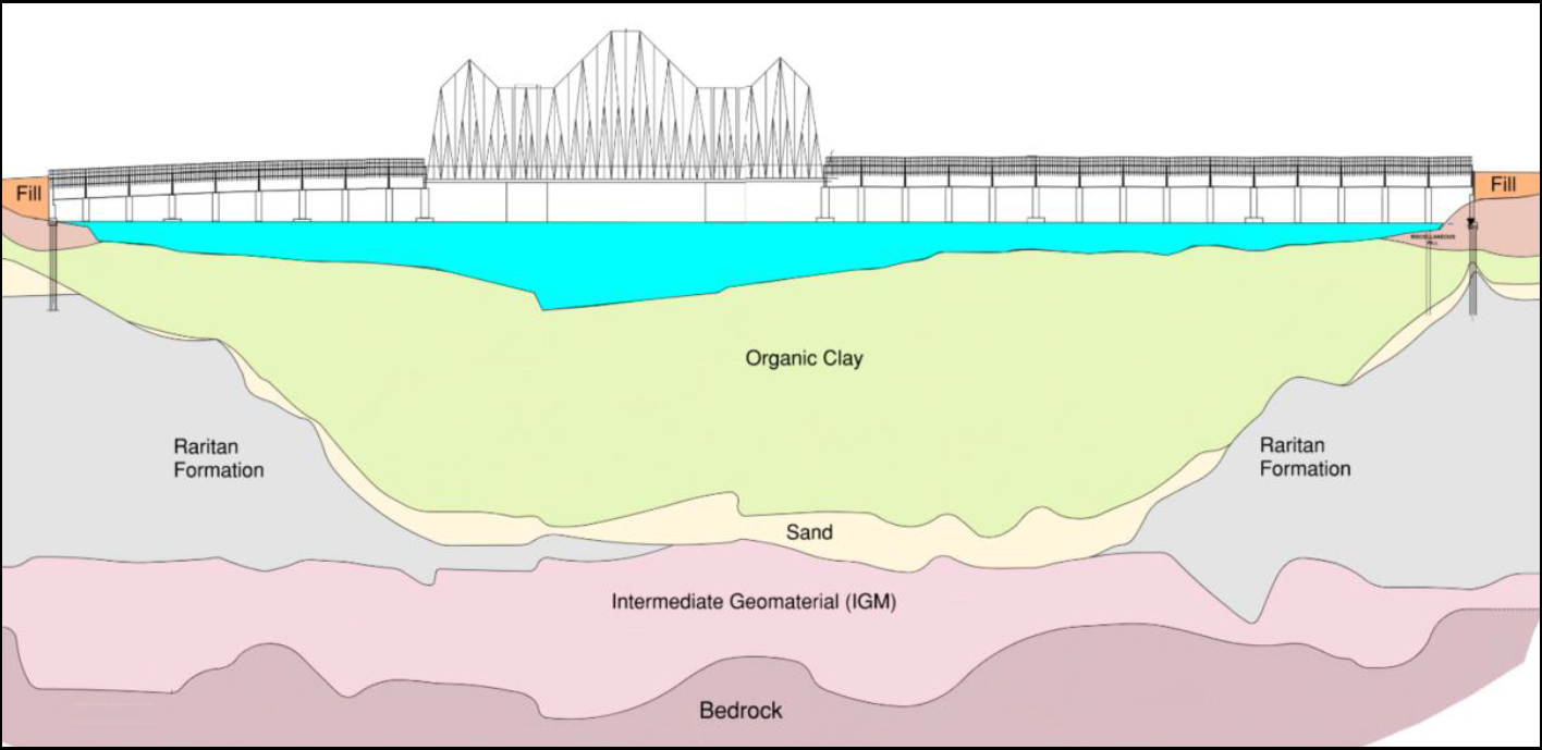
NJ TRANSIT is replacing the now 117 year old structure, which was submerged and severely damaged by storm surge during Superstorm Sandy which battered the NJ Coastline in the fall of 2012. Immediately following the storm, both rail and marine traffic were forced out of service for an eighteen day period, which had significant impacts to local communities and the region. The existing bridge includes 28 steel multi-girder approach spans and a steel truss swing span carrying two rail tracks over the Raritan River. The 2,920’ long bridge services NJ TRANSIT’s North Jersey Coastline passenger rail as well as Conrail Freight routes between numerous points along the New Jersey Shore and the urban centers of Newark, NJ and New York City. In addition to the damage from Superstorm Sandy, mechanical / electrical operational issues have plagued the bridge in recent years. NJ TRANSIT has implemented numerous costly repair and rehabilitation contracts to extend the bridge’s functionality as it is near the end of its useful service life.
The bridge replacement features a new offline replacement structure, including twenty-four (24) steel multi-girder approach spans (each 95’ long), two 188’ long steel truss flanking spans, two 50’ long, 220’ high steel tower spans, and a 376’ long truss vertical lift span. When opened, the bridge will provide 110’ vertical clearance over a 300’ wide navigation channel. Phase 1 of the bridge construction is now complete and includes the various bridge foundations and multi-girder approach structures. Local strata consisting of soft river deposits overlying variable sand, cohesive soils, intermediate geomaterials, and rock presented challenging subsurface conditions and heavily impacted the design and construction of bridge foundations. In addition to conventional strength requirements, the foundation design was influenced by stringent serviceability demands, scour effects, and overall bridge stiffness requirements under railroad loading.
This presentation summarizes how subsurface considerations influenced foundation type selection, and final pier support layouts. Various configuration water piers are supported on large-diameter drilled shafts, while abutments and retaining walls are founded on steel pipe piles. Particular emphasis is given to the role of longitudinal bridge behavior in establishing lateral stiffness demands at the substructure level, including the influence of shaft group configuration and foundation stiffness on computed bridge displacement. It also outlines key construction and verification measures implemented to support foundation construction and acceptance. These included installation methods appropriate for river conditions, integrity testing of completed shafts, and load testing of demonstration foundation elements. The test data were used to compare observed performance with design assumptions and to support final foundation acceptance. Finally, this case study highlights the importance of serviceability, subsurface variability, and constructability in the selection and design of deep foundations for railroad bridges in soft river deposits.

Robert D. Friedman, AggreBind Technologies
Robert Friedman is an inventor and global authority in nano-based polymer technologies for soil stabilization, dust control, and waste encapsulation. Since 2013, he has led AggreBind’s development of sustainable infrastructure solutions used worldwide. He holds nine international patents, is a Research Gate Affiliate Member of the American Society of Civil Engineers, and a Senior Member of the American Chemistry Council. His work has been published in multiple engineering journals, and he is a contributing author to the NEx Guideline for Soil Stabilization. Mr. Friedman has lectured globally, including at the University of Architecture Civil Engineering and Geodesy in Bulgaria, and holds a B.A. in Comparative Religion from Boston University.
Sustainability and Circularity with Green Construction Materials
Demand for sustainable and durable road infrastructure is growing; conventional road construction is expensive and environmentally problematic, with quarrying, transport of aggregate and the application of asphalt. AggreBind is a pioneer in green construction, supporting biodiversity with its proprietary soil stabilizer. By utilizing advanced polymer nanotechnology to bind soil particles, AggreBind delivers environmentally friendly, low-carbon, low-cost, long-lasting and impermeable roads with enhanced structural integrity and significantly reduced environmental impact.
This presentation examines real-world applications and proposes strategies for broader industry uptake to positively impact both industry and environment.
AggreBind’s patented long-string cross-linking technology binds in-situ soils through a process of ‘AggreBinding’, forming a multi-dimensional interlocking mass that is solid, load-bearing and water-resistant; used to build roads and airstrips, both private and Government, with or without wearing surfaces. AggreBind works with recycled materials, waste and hazardous waste materials.
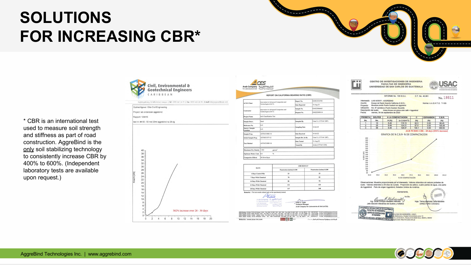
Independent laboratory testing conducted for implemented projects demonstrates an increase of 400% to 600% CBR. An AggreBind road is a solid, smooth surfaced road that consistently saves 12% - 20% on asphalting, and, depending on conditions, a reduction in the total asphalt used by up to 50%, lowering the carbon footprint proportionately. The solid, hydrophobic base prevents the ingress of water, the main cause of potholing and asphalt deterioration, reducing costly road repairs. AggreBind's technology offers a replicable, sustainable and environmentally friendly model for road construction to:
- Lower the carbon footprint
- Reduce environmental impact
- Reduce overall upfront construction, as well as ongoing maintenance costs
- Contribute to community development and infrastructure

Bruma Souza, Ph.D., Weston & Sampson
Bruma Souza is a Geotechnical Engineer at Weston & Sampson in Reading, Mass. She received her master’s from the University of New Hampshire in 2021 and her PhD from UNH and the University of Lyon, France, in 2024. She works in geotechnical consulting and has a strong interest in research focused on in situ testing. Her primary research interests include rockfalls and Measurement While Drilling.
From the Rock Perspective: Advancing Rockfall Hazard Assessment Using Smart Rock IMU Technology
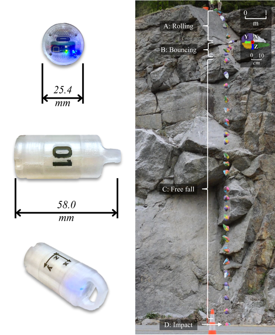
Rockfall hazard assessment for transportation corridors commonly relies on trajectory modeling approaches that use empirically selected input parameters, which may not accurately represent site-specific conditions. This limitation is partly due to the difficulty of obtaining field measurements that fully capture the movement of a falling block and its interaction with the ground. In this context, Smart Rock (SR) sensors have emerged as a useful geotechnical instrumentation tool capable of measuring rockfall motion directly from the perspective of the falling block.
Smart Rocks consist of Inertial Measurement Units (IMUs) equipped with triaxial accelerometers and gyroscopes that record acceleration, rotation, and impact behavior during rockfall events. IMUs have become widely used in modern engineering applications, including aircraft navigation systems, autonomous vehicles, drones, robotics, smartphones, wearable devices, and virtual reality platforms, where accurate motion sensing and orientation tracking are required. More recently, IMU technology gained worldwide visibility during the FIFA World Cup through instrumented match balls that transmitted high-frequency motion data to support ball tracking and semi-automated offside decisions, demonstrating the versatility of these sensors in capturing complex dynamics under real-world conditions.
This presentation summarizes the principal methods and findings of a five-year experimental research program conducted at the University of New Hampshire in collaboration with the New Hampshire Department of Transportation (NHDOT), the Vermont Agency of Transportation (VTrans), and partner institutions. Developed and refined over the past two decades, Smart Rock technology consists of small 3D-printed capsules containing a combination of high-g and low-g
accelerometers, high-rate gyroscopes, and an altimeter that can be embedded within natural or fabricated rock blocks. Data collected from more than 400 controlled and in situ rockfall tests across sites in the northeastern United States and France were evaluated alongside high-speed camera measurements and ground characterization methods.
The experimental results demonstrate that acceleration and rotational velocity measurements can reliably distinguish different modes of rockfall motion, including at-rest conditions, free fall, rolling, sliding, bouncing, and impact. Distinct sensor output patterns were consistently identified and validated through synchronized video observations. The sensors also provided direct measurements of resultant accelerations, rotational velocities, and impact forces, offering
insights into block-ground interaction that cannot be captured through conventional field observations alone.
Comparisons between Smart Rock measurements and conventional rockfall models revealed important discrepancies between observed and predicted behavior. While existing models generally reproduced overall trajectory patterns, they frequently overestimated rotational velocities following impacts and did not always accurately predict bounce behavior and runout distances. Recent controlled experiments further demonstrated that Smart Rock data can be used to characterize terrain response and support the selection of model input parameters, including coefficients of restitution and friction values for different ground materials.
Overall, the findings confirm that Smart Rock instrumentation provides a unique and practical means of quantifying rockfall kinematics and improving understanding of block-ground interaction. By providing measurements from within the moving rock itself, Smart Rocks offer a pathway toward more representative model calibration, improved prediction accuracy, and more reliable design of rockfall mitigation measures for transportation infrastructure and other risk-exposed assets.
Jim Davis, P.E., GZA GeoEnvironmental
Jim is an Associate Principal at GZA with over 17 years of experience. He received his BS from URI and masters from NC State. Jim’s primary projects include dams, private developments, energy, and universities.
Overview of Connecticut Building Code Changes

Cassandra Champagne, Ph.D., University of New Haven
Cassandra Champagne joined the Department of Civil and Environmental Engineering as an Assistant Professor of Practice in Spring 2023. Prior to that, she served as an adjunct instructor for the department, teaching geotechnical engineering courses since Fall 2020. Cassandra’s background is in geotechnical engineering, geoenvironmental engineering, and remote sensing. During her graduate studies at the University of Michigan, Cassandra researched bioreactor landfill settlement using 3D models generated from aerial drone imagery and developed correlations between cone penetration test (CPT) data and soil parameters related to foundation bearing capacity design for the Michigan Department of Transportation. She also worked as an earth retention design engineer at G2 Consulting Group in Michigan, where she designed braced excavations, retaining walls, cofferdams, and more. Cassandra currently also serves as the CT Valley Geo-Institute Committee Chair with the Connecticut Society of Civil Engineers.
CPT for Site Variability and Uncertainty Assessment

Andy Chakraborty, P.E., Dennis Quinit, P.E., and Soham Chakraborty, KS Engineers
Andy Chakraborty, P.E., is the Vice President and Manager of Connecticut Operations for KS Engineers. Dennis Quinit, P.E., is the Lead Structural Engineer for KS Engineers. Soham Chakraborty is a Senior Year Student of Xavier High School Middletown, CT
Simulation of Soil-Structure Interaction of Highway Overhead Sign Structures Subjected to Combined Loading Including Torsion
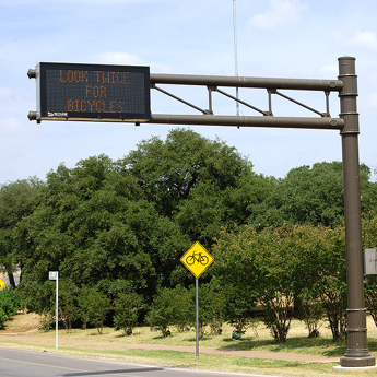
Highway overhead sign structures supported by a single column—most cantilevered or monotube systems—are increasingly adopted by U.S. State Departments of Transportation (DOTs) due to their improved aerodynamics, fatigue resistance, and reduced maintenance requirements. These structures typically rely on a single drilled shaft foundation, which offers ease of construction and minimal site disturbance. Under wind and seismic loadings, however, drilled shafts are subjected to complex combinations of axial force, bending, shear, and torsion. Current guidance, such as that published by the Illinois and Florida DOTs, employs depth dependent soil springs to capture soil–structure interaction under these combined demands. Yet, these approaches do not account for shear–torsion interaction within the soil response, potentially leading to unconservative estimates of foundation capacity. To address this gap, this study develops modeling recommendations for simulating drilled shaft behavior under combined loading using OpenSees. Both the shaft and soil are modeled as three-dimensional solid elements in OpenSees to capture the interaction between shear and torsion in soils. The modeling technics will be presented in this study. A case study based on an inservice sign structure designed by a U.S. DOT will also be used to benchmark OpenSees results against those obtained from a commercial finite element analysis in Abaqus. Findings from this study will support improved implementation of soil–structure interaction in the design of single support highway sign foundations.

Luis Navarrete, GZA GeoEnvironmental
Luis Navarrete is a geologist specializing in geotechnical investigations, subsurface characterization, and rock slope engineering. His experience includes geologic mapping, drilling and instrumentation programs, construction oversight, and geotechnical evaluations for residential, commercial, transportation, and environmental projects. Mr. Navarrete manages subsurface investigation programs, develops 3D geologic and geotechnical models, and supports the design and implementation of rock slope stabilization and mitigation projects throughout the northeastern United States.
Michael P. Smith, P.E., Associate Principal / Metro-Boston Geotechnical Group Leader, GZA GeoEnvironmental
Mr. Smith has over 20 years of experience in consulting and construction and the geotechnical group leader for GZA’s Metro-Boston division. Mr. Smith has worked on a wide array of projects across the United States that includes large-scale private, municipal, industrial and infrastructure projects. Mr. Smith specializes in heavy civil construction for buildings and infrastructure and has experience related to construction over soft or difficult soil conditions, shallow foundations, piles, drilled shafts, micropiles, tiebacks, soil nails, ground improvement, deep excavations, retaining walls, geotechnical instrumentation and redevelopment of existing sites.
Carving a Cliff: A New Biomed Campus
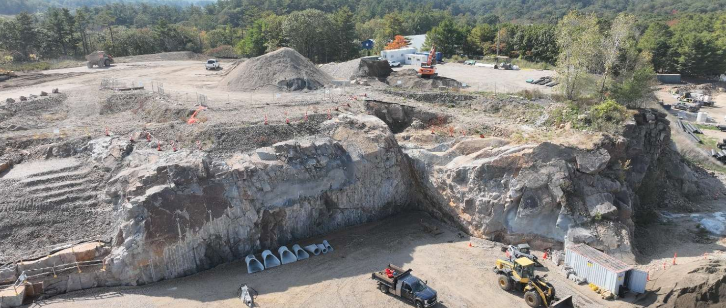
In January 2022 GZA GeoEnvironmental (GZA) was retained to perform a due diligence geotechnical study of a 50-acre former quarry site proposed for redevelopment as a biomedical campus. The site included a 700-foot-long rock slope, ranging from 15 to 45 feet in height, with irregular geometry, overhangs and joint spacing from historic uncontrolled quarrying methods making it prone to rockfall. Following site acquisition, the project vision evolved significantly. The design team proposed constructing the primary building to step over the existing rock cliff, incorporating a central 45-foot-tall exposed rock face as a defining architectural feature. Construction was planned in two phases, with all blasting required during Phase 1 due to sensitivity of future medical equipment. This vision necessitated a rigorous evaluation of the rock slope to address stability, constructability, and long-term performance.
GZA subsequently recommended and performed an in-depth rock slope assessment to support development of the campus, including multiple investigations, rope-access rock mapping, design coordination, and construction-phase engineering services. It performed a rock slope investigation in 2023 incorporating drone-based photogrammetry, rope-access rock mapping, and iterative design coordination. A photogrammetric point cloud was used to conduct stability assessments, identify access constraints, and plan safe rope-access routes. This data informed stabilization recommendations for blasted vertical rock faces surrounding the Phase 1 and Phase 2 building foundations, a parking garage, and rockfall catchment at the base of the central cliff.
Slope stabilization began in July 2024 and included line drilling, controlled blasting, scaling, rock dowels, shotcrete buttressing, and a combination secured and passive wire mesh systems. Construction challenges included variable blast performance, evolving face geometry, access limitations, and refining scaling practices. Throughout construction, frequent drone surveys and photogrammetric models were used to monitor changing rock face conditions, refine stabilization measures, adjust dowel layouts, and enhance construction-phase decision making, representing a novel application of aerial modeling during active rock slope stabilization. Stabilization of the Phase 1 building rock face was completed in August 2025. Stabilization of Phase 2 is proposed to be completed in the future and is anticipated to encounter similar conditions and challenges.
This presentation highlights the state of rock slope engineering practices leveraging drone-based methods with rope-access investigations for design as well as provide adaptive construction-phase support to overcome complex geologic conditions and achieve our client’s project goals.
7:30 AM – 8:00 AM Breakfast & Registration
8:00 AM – 4:15 PM - Conference Program
4:20 PM – 4:30 PM Closing Remarks & PDH Processing
4:30 PM – 6:00 PM Networking Reception with Drinks and Refreshments
Sheraton Hartford South, 100 Capital Boulevard, Rocky Hill, CT 06067
Discounted Rooms will be reserved on the Thursday before this Conference. Click here for the discount room reservation link.
A Note about Photographs - People participating in CSCE events may be photographed by individuals and/or a photographer hired by CSCE. These photographs may appear without compensation or notice in online, printed or electronic materials related to CSCE. People who do not want to be photographed should contact Amy Petrone, CSCE Administrative Assistant, by email at [email protected] or [email protected] or by phone at (860) 879-2723.
Early Registration Rates before September 12, 2026 / Regular Registration Rates
ASCE Member - Includes NYS PDHs - $275.00 / $325.00
Non ASCE Member - Includes NYS PDHs - $350.00 / $375.00
Government Employee, Faculty and Retired Person - Includes NYS PDHs - $100.00 / $120.00
Younger Member - Under 35 Years of Age & Includes NYS PDHs - $175.00 / $200.00
Student/Faculty Registration - ID Required at Registration - No NYS PDHs - $25.00 / $35.00
Exhibitor – $800 (Includes 1 Attendee and 1 Exhibit Table, selection of table location first come, first served)
Additional Exhibitor - Each exhibit table includes 1 exhibitor. Once an exhibit table is purchased, additional exhibitors may register separately for $150 each. No NYS PDH’s are included with exhibitor table or additional exhibitor registrations.
Exhibitor Layout (also at the top of this page)
Exhibitors have long supported our events and can offer solutions for our projects. At our past workshops, seminars and conferences, geotechnical suppliers, contractors, and service providers displayed their latest products for design professionals, contractors, owners, and academicians. We are always looking for exhibitors to join us at our events.
Sponsors have long supported our events and can offer solutions for our projects. At our past workshops, seminars and conferences, geotechnical suppliers, contractors, design engineers, and service providers have sponsored our events to help make them successful and to raise money for CSCE’s Scholarship Fund.
Bedrock Sponsor - 2 Available SOLD OUT - $2,500
This sponsorship level includes prominent display of logo on promotions and program, 1st selection of premier exhibitor booth location (Exhibitor table not included, must register separately), invitation for 2 to the reception dinner on October 1st, podium mentions, and 2 attendee registration. Please submit your logo to [email protected] after you register for the conference.
Friday Reception Sponsor - 1 Available - $2,000
This sponsorship level includes display of logo on promotions, 1 invitation for reception dinner on October 1st, your company logo on table placards during the reception immediately following the conference, podium mentions, and 1 attendee registration. Please submit your logo to [email protected] after you register for the conference.
Breakfast Sponsor - 1 Available - $1,800
This sponsorship level includes 1 invitation for reception dinner on October 1st, your company logo on table placards during breakfast, podium mentions, and 1 attendee registration. Please submit your logo to [email protected] after you register for the conference.
Foundation Sponsor - 3 Available 1 LEFT - $1,600
This sponsorship level includes display of logo on promotions and program, advance selection of exhibitor table location (exhibitor table not included, must register separately), 1 invitation for reception dinner on October 1st, your company logo on table placards, podium mentions, and 1 attendee registration. Please submit your logo to [email protected] after you register for the conference.
Concrete Sponsor - 5 Available 2 LEFT - $1,000
This sponsorship level includes display of logo on promotions and program, 1 invitation for reception dinner on October 1st, podium mentions, and 1 attendee registration. Please submit your logo to [email protected] after you register for the conference.
How we got here...2026 CALL FOR ABSTRACTS
The Connecticut Valley Chapter of the ASCE Geo-Institute is pleased to invite practitioners, contractors, researchers, educators, and vendors to submit abstracts for presentations at our 2026 GEO-CONNECTICUT Conference.
We are seeking 25-minute in-person presentations (followed by a 5-minute Q&A session) on a wide range of geotechnical engineering topics, with an emphasis on innovative technologies, practical solutions, and real-world applicability. We welcome submissions from across the geotechnical engineering community and encourage presentations that showcase innovative practices, unique challenges, case studies, interesting construction projects, and applicable research.
Event Details: Date: Friday, October 2, 2026 Time: Approximately 8:00 AM – 4:00 PM Location: Sheraton Hartford South in Rocky Hill, CT For inspiration, please view past speakers and abstracts at the bottom of this webpage: https://sections.asce.org/ | Submission Guidelines: Abstract Length: 250–500 words Visual: Include one photo/graphic that illustrates the topic Format: In-person only; presentation only (no written paper required) Deadline: Friday, August 7, 2026 Please click here to submit an abstract or email it to [email protected]. |
If you have any questions or concerns, you may email, call, or text the following contacts:
Amy Petrone, CSCE Administrative Assistant, [email protected], 860-879-2723
Cassandra Champagne, CT Valley Chapter of the ASCE Geo-Institute, [email protected], 401-440-6704